


Good Sunday night!
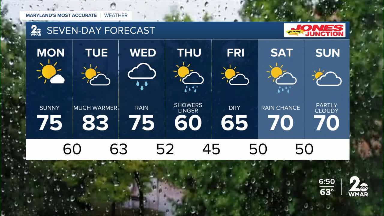
The workweek gets off to a gorgeous start, with plenty of sunshine and temperatures in the 70s on Monday.
Clouds will begin to increase late Tuesday ahead of our next weather maker, which is set to bring rain Wednesday and Thursday. A slow-moving front will stall across the region, leading to periods of rain fueled by strong southerly winds acting like a conveyor belt, drawing tropical moisture into the area. Most forecast models agree that many locations could pick up between a half inch and an inch of rain by the time it all wraps up.
While severe weather is not expected, a rumble of thunder or two cannot be ruled out late Wednesday into Thursday.
Colder temperatures are set to follow for the second half of the week.
Dylan

Monday
Mostly sunny, with a high near 76. Southwest wind 6 to 10 mph.
Monday Night
Partly cloudy, with a low around 60. Southwest wind around 7 mph.
Tuesday
Mostly sunny, with a high near 83. Southwest wind 8 to 14 mph, with gusts as high as 24 mph.
Tuesday Night
A chance of showers, mainly after 2am. Mostly cloudy, with a low around 63. South wind around 11 mph, with gusts as high as 21 mph. Chance of precipitation is 40%.
Wednesday
Showers, with thunderstorms also possible after 2pm. High near 74. Chance of precipitation is 90%.
Wednesday Night
Showers likely and possibly a thunderstorm. Mostly cloudy, with a low around 51. Chance of precipitation is 70%.
Thursday
Showers. High near 60. Chance of precipitation is 80%.
Thursday Night
Showers likely before 8pm. Partly cloudy, with a low around 43. Chance of precipitation is 60%.
Friday
Sunny, with a high near 65.
Friday Night
Partly cloudy, with a low around 50.
Saturday
A chance of showers. Partly sunny, with a high near 67. Chance of precipitation is 50%.
Saturday Night
A chance of showers. Partly cloudy, with a low around 50. Chance of precipitation is 30%.
Sunday
Mostly sunny, with a high near 71.

