

BALTIMORE — Happy Wednesday! A Heat Advisory goes into effect from 11 AM - 8 PM as afternoon temperatures climb near 100° with heat index values around 106°. There won't be much relief overnight, as temperatures only drop into the 70s. A spotty afternoon thunderstorm could pop up, but most areas remain dry. The peak of the heatwave occurs Thursday and Friday, when an Extreme Heat Watch is in effect. Heat index values could top 112°, making this our most dangerous stretch of heat so far this summer. Scattered afternoon and evening thunderstorms are expected to develop during the holiday weekend, and some could become severe.
Have a sunny day!

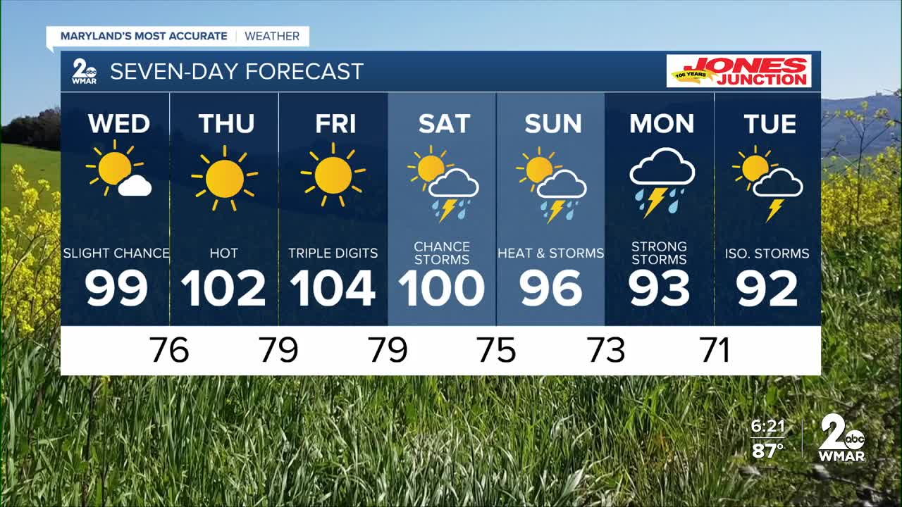
7 Day Forecast:
Today A slight chance of showers and thunderstorms. Sunny and hot, with a high near 99. Heat index values as high as 107. Southwest wind 5-10 mph.
Tonight Mostly clear, with a low around 76. South wind 5-10 mph, with gusts as high as 24 mph.
Thursday Sunny and hot, with a high near 102. Heat index values as high as 109.
Thursday Night Mostly clear, with a low around 79.
Friday A chance of showers and thunderstorms. Sunny and hot, with a high near 104.
Friday Night A chance of showers and thunderstorms. Partly cloudy, with a low around 79.
Independence Day A chance of showers and thunderstorms. Mostly sunny and hot, with a high near 100.
Saturday Night A chance of showers and thunderstorms. Mostly cloudy, with a low around 76.
Sunday A chance of showers and thunderstorms. Partly sunny, with a high near 97.
Sunday Night Showers and thunderstorms likely. Mostly cloudy, with a low around 73.
Monday Showers likely and possibly a thunderstorm. Partly sunny, with a high near 94.
Monday Night Showers and thunderstorms likely. Mostly cloudy, with a low around 72.
Tuesday A chance of showers and thunderstorms. Partly sunny, with a high near 92.

