

BALTIMORE — We are heading into a fantastic stretch of early summer conditions. Sunshine will be the dominant theme through the end of the workweek, with comfortable temperatures in the low to mid 80s Wednesday and Thursday.
Humidity levels will remain manageable, making it a great time to get outside and enjoy the longer daylight hours. By Friday and Saturday, the summer heat begins to flex its muscles as temperatures climb into the lower 90s across much of the Baltimore metro area under mostly sunny skies.
The pattern starts to change a bit as we head into the second half of the weekend. While Sunday won't be a washout by any means, there will be a chance for a few showers and thunderstorms as a disturbance approaches from the north.
The timing and coverage of any storms remains somewhat uncertain, but it's enough to keep an eye on if you have outdoor plans. Even with the storm chance, temperatures should remain quite warm, with highs pushing into the upper 80s.
Dylan

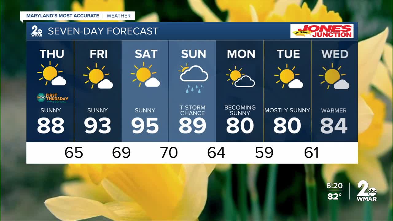
7 Day Forecast:
Thursday Sunny, with a high near 88.
Thursday Night Mostly clear, with a low around 65.
Friday Sunny, with a high near 93.
Friday Night Mostly clear, with a low around 69.
Saturday Mostly sunny, with a high near 95.
Saturday Night Mostly cloudy, with a low around 70.
Sunday A chance of showers. Partly sunny, with a high near 89.
Sunday Night A chance of showers and thunderstorms. Mostly cloudy, with a low around 64.
Monday A chance of showers and thunderstorms. Partly sunny, with a high near 80.
Monday Night A chance of showers and thunderstorms. Mostly cloudy, with a low around 59.
Tuesday A chance of showers. Partly sunny, with a high near 80.
Tuesday Night Partly cloudy, with a low around 61.
Wednesday Mostly sunny, with a high near 84.

