


BALTIMORE — Good Thursday night!
The vast majority of the storms have finished for tonight, however, our high resolution models depict some additional storm formation near the Eastern Shore between midnight-5am!
Friday starts off mostly cloudy, with peeks of sunshine developing by late morning.
Our next round of rain pushes northward Saturday, leading to widespread showers. Models are trending a bit drier on Sunday, albeit we'll still maintain spotty showers.
Forecast confidence drops Mon & Tue as uncertainty lingers with regards to the tropics. Models show a new tropical storm forming and pushing northward, possibly making landfall in the Carolina's as early as Mon night/Tue AM. Whether or not we see impacts from Imelda will depend on the strength of high pressure to our north. The vast majority of the models keep the storms rainfall to our south, but a 200 mile jog in the storm track to the north could change that!

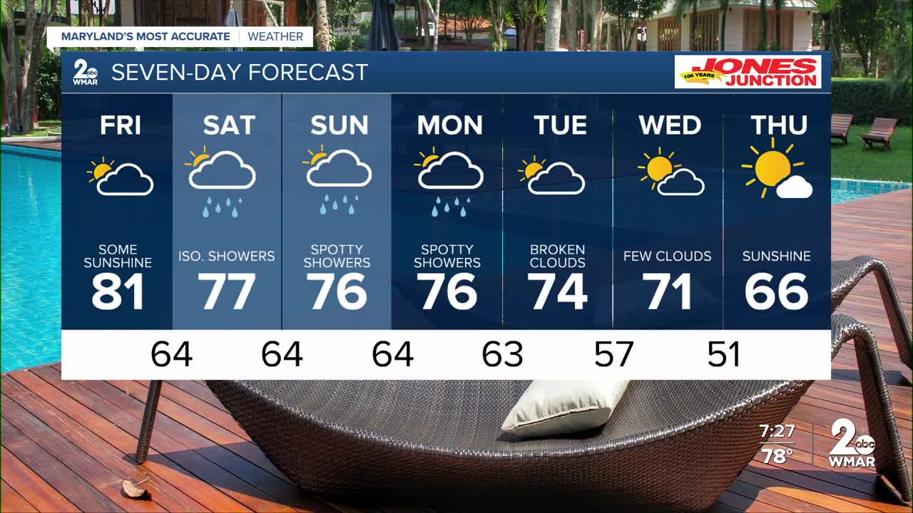
7 Day Forecast:
Friday Partly sunny, with a high near 80.
Friday Night Mostly cloudy, with a low around 64.
Saturday A chance of showers. Mostly cloudy, with a high near 76.
Saturday Night Showers likely and possibly a thunderstorm. Cloudy, with a low around 64.
Sunday A chance of showers. Mostly cloudy, with a high near 75.
Sunday Night A chance of showers. Mostly cloudy, with a low around 64.
Monday A chance of showers. Mostly cloudy, with a high near 76.
Monday Night A chance of showers. Mostly cloudy, with a low around 63.
Tuesday Partly sunny, with a high near 75.
Tuesday Night Partly cloudy, with a low around 57.
Wednesday Partly cloudy, with a high near 71.
Wednesday Night Partly cloudy, with a low around 51.
Thursday Mostly sunny, with a high near 66.

