


Good Sunday evening!
Satellite and radar imagery show the low-pressure system responsible for today’s snow is quickly moving out of the region. Snow will taper off tonight, but slick spots may linger on untreated roads.
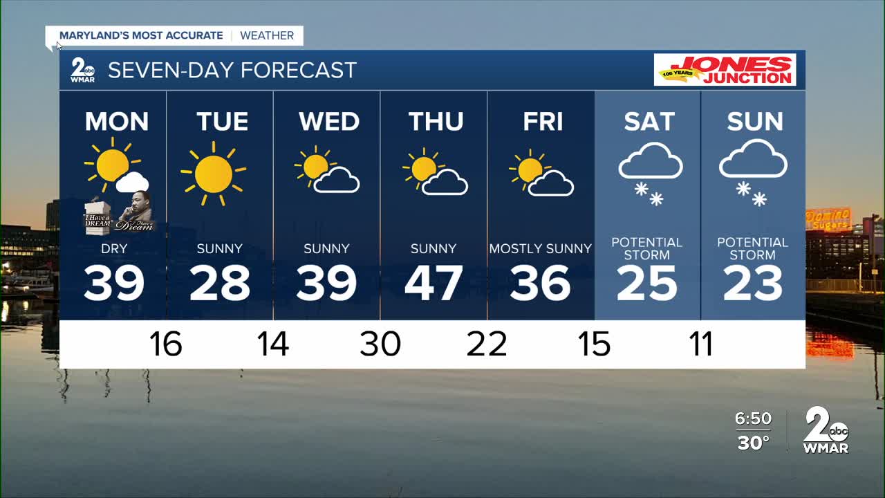
Sunshine is expected Monday through Wednesday, accompanied by a bitter blast of cold air. Temperatures will moderate briefly on Thursday before an even colder pattern settles in heading into next weekend.
The upcoming week looks dry overall, but the pattern becomes more active next weekend as we monitor another potential coastal storm. With plenty of cold air in place across the Mid-Atlantic, any storm tracking close to our area would likely bring snow.
Please drive safely, especially on untreated roads.
— Dylan

M.L.King Day
Sunny, with a high near 39. Light and variable wind becoming west 9 to 14 mph in the morning. Winds could gust as high as 24 mph.
Monday Night
Mostly clear, with a low around 15. West wind 8 to 14 mph, with gusts as high as 24 mph.
Tuesday
Sunny, with a high near 27. West wind 8 to 14 mph, with gusts as high as 23 mph.
Tuesday Night
Mostly clear, with a low around 13.
Wednesday
Sunny, with a high near 38.
Wednesday Night
Mostly cloudy, with a low around 29.
Thursday
Partly sunny, with a high near 43.
Thursday Night
Mostly clear, with a low around 20.
Friday
Mostly sunny, with a high near 36.
Friday Night
Partly cloudy, with a low around 22.
Saturday
A chance of rain and snow. Mostly cloudy, with a high near 33. Chance of precipitation is 30%.
Saturday Night
A chance of snow. Mostly cloudy, with a low around 17. Chance of precipitation is 40%.
Sunday
A chance of snow. Partly sunny, with a high near 25.

