


Good Monday night!
The Storm Prediction Center has issued a level 2/5 risk for severe storms Tuesday. Here's what we know:
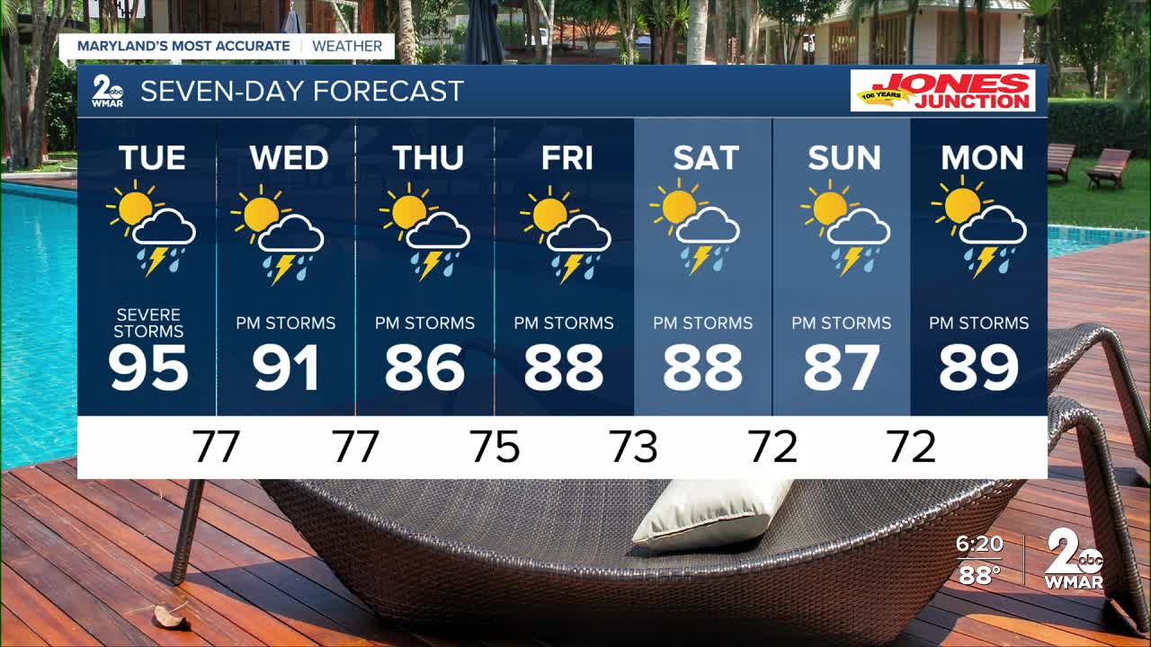
• Timing: 3pm until 8pm
• Threats: Hail, damaging wind, flooding, and isolated weak tornadoes
• Heat Advisory remains in effect through Tuesday due to heat indices of 107°F +
A frontal boundary will gradually through the Ohio Valley on Tuesday, leading to the threat of severe storms. Ahead of the front, high heat and humidity associated with daytime heating will fuel these storms. The biggest threats will be winds in excess of 57 mph and 1" inch diameter hail. The tornado threat is low, but not non-existent. Sometimes these weather setups can lead to weak tornadoes.
Late day showers and storms continue each day this week. Model information shows by the end of this week total rainfall accumulation could exceed 3" in some regions! This means low-lying areas may see some flooding.


Tuesday Sun in the morning with afternoon storms. High near 95. Heat index values as high as 102.
Tuesday Night Showers and thunderstorms likely before 2am, then a slight chance of showers. Mostly cloudy, with a low around 77.
Wednesday A slight chance of showers, then a chance of showers and thunderstorms after 11am. Partly sunny, with a high near 90.
Wednesday Night A chance of showers and thunderstorms. Mostly cloudy, with a low around 77.
Thursday A chance of showers, then showers and possibly a thunderstorm after 2pm. High near 87.
Thursday Night Showers and possibly a thunderstorm, mainly before 2am. Low around 75.
Friday Showers likely and possibly a thunderstorm, mainly after 2pm. Mostly cloudy, with a high near 87.
Friday Night Showers and thunderstorms likely. Mostly cloudy, with a low around 73.
Saturday A chance of showers and thunderstorms. Partly sunny, with a high near 89.
Saturday Night A chance of showers and thunderstorms. Mostly cloudy, with a low around 72.
Sunday A chance of showers and thunderstorms. Partly sunny, with a high near 90.

