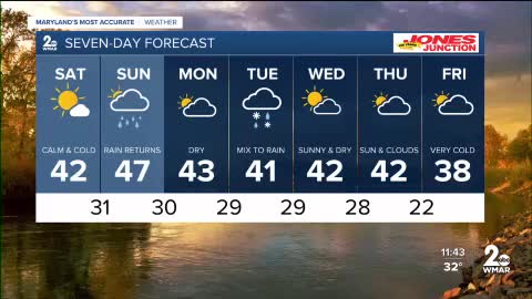


As we head into the weekend, Saturday is shaping up to be the better of the two days. Expect plenty of sunshine to start, with increasing clouds and a higher chance of rain on Sunday.
The weather briefly dries out on Monday before our attention turns to a much stronger coastal storm arriving Tuesday.
Coastal storms can be tricky—just a 100-mile shift in the storm’s track can mean the difference between a wintry mix of snow, rain, and freezing rain, or an all-rain event.
Over the past several hours, forecast models have nudged the storm’s track farther north and west, favoring a warmer outcome and mostly rain for our area. I expect a brief period of rain and snow early Tuesday, quickly changing to all rain as temperatures rise. At this time, I do not anticipate a winter storm for central or eastern Maryland. However, if the low-pressure system shifts about 100 miles east, an icy mix could still develop.
Stay safe this weekend, and we’ll continue to keep you updated as conditions evolve!


Saturday Sunny, with a high near 43.
Saturday Night Mostly cloudy, with a low around 30.
Sunday Rain likely. Cloudy, with a high near 45.
Sunday Night Partly cloudy, with a low around 31.
Monday Mostly sunny, with a high near 45.
Monday Night A chance of rain and snow after 1am. Mostly cloudy, with a low around 29.
Tuesday Rain likely. Mostly cloudy, with a high near 39.
Tuesday Night A chance of rain. Mostly cloudy, with a low around 28.
Wednesday Sunny, with a high near 41.
Wednesday Night Partly cloudy, with a low around 26.
Thursday Partly sunny, with a high near 44.

