


BALTIMORE — Waking up this morning reminds us that the colder months are fast approaching. As we enter winter everyone begins to wonder about snow and how much we may see for the season.
Last year, we experienced one of the least snowiest winters despite having outbreaks of colder arctic air. The season total at BWI airport, our official record-keeping site, was a paltry 0.2" beating the old record set back in the winter of 1949-50 where we saw only half an inch of snow during the entire year.
But if you are a snow lover this winter is one to be hopeful for.
As we continue the march into our first El Niño winter in three years and it is looking to be a stronger one, which raises our chances for higher snowfall amounts.
First, let us explain what an 'El Niño' is.
El Niño is one-half of the larger El Niño-Southern Oscillation. This global weather phenomenon is when a stretch of water in the southern Pacific Ocean begins to warm and creates a different weather pattern over the continental U.S.
This ends up creating the perfect setup for larger storms to hit the east coast and specifically the Mid-Atlantic. This setup is what normally brings us the blockbuster type of storms, such as nor'easters.
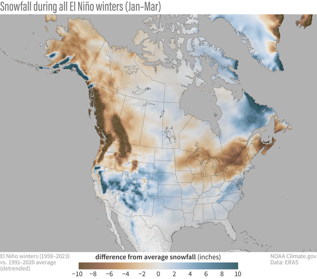
When we compare the snowfall difference between all winters compared to all El Niño winters, we have a noticeably higher amounts of snowfall by about two to four inches of snowfall.
But during stronger El Niño winters, classified between moderate and strong, we see a much larger difference compared to the average.

And in the last 33 winters, we still see this trend being the case. Our average yearly snowfall is around 15.6 inches of snow, while all El Niño winters average just under two feet, and strong moderate to strong El Niños average closer to 30 inches.

A big reason for the elevated big storm potential is the slightly warmer temperatures that are seen during the El Niño winters. This allows for more water vapor to be carried in our atmosphere but also lets the polar jet stream shift and get closer to the Mid-Atlantic giving us just the right ingredients to create the big storm.
But just because we have the right ingredients does not mean that we are a slam dunk for a big one to hit this year. We can look at two similar years in terms of El Niño strength but vastly different snowfall amounts to explain this.
2015-2016 and 1997-1998 both have very similar numbers in terms of the amount of warmth there was in the El Niño affected waters, which classified both as very strong. We can all remember what January 2016 was like as we had the big nor'easter that dropped over 30 inches of snow that season. But in 1997-1998, we saw barely over an inch of snow for the entire winter.
This highlights just how boom or bust an El Niño winter can be, just liking making caramel, if the timing is not right you get burned no matter how perfect your ingredients were.
While we are in that boom or bust situation, we can find a glimmer of hope in that we have seen some of our snowiest winters under this El Niño setup.

Our top 5 snowiest El Niño winters have seen snowfall amounts well over 30 inches with our snowiest season being the winter of 2009-2010, or as I and many other students at the time knew it, the year we had two winter breaks as we saw over 70 inches of snow at BWI airport.
As the holiday season begins to quickly approach us, be sure to have the snow shovel accessible in case we do start seeing signs of a snowstorm brewing. Until then, be sure to enjoy the sunshine and last few weeks of fall in the Mid-Atlantic because winter will be here sooner rather than later.

