


BALTIMORE — Good Saturday to you.
Temperatures are mild for the afternoon, with sunshine poking in and out. Conditions will remain stable throughout the day, with no significant changes, until the overnight hours of Sunday. Sunday brings the possibility of a Winter Storm to the region.

A Winter Storm Watch has been issued for the area through 10 A.M. on Monday.
Winter Storm Warning for Kent and Queen Anne's County until 6:00pm Monday.
Blizzard Warning for Dorchester, Wicomico, Somerset and Worcester County until 7:00pm Monday.
Winter Storm Warning for Frederick, Carroll, Baltimore, Cecil, Washington, Anne Arundel, St. Marys and Calvert County until 10:00am Monday.
Even with this, there is still a lot of uncertainty with this storm system. What starts off as heavy rain is expected to turn to snow during the evening hours. A possible influence of a Nor'easter will add to the overall moisture to tap into. There are models and accredited outlets, like the National Weather Service, giving wide ranges for totals. With a system as complex as this, that can be expected. To our best understanding of the information we have been given, Maryland's Most Accurate is narrowing the range of totals down to 4 to 8 inches for the county and surrounding metropolitan areas north of the I-95 corridor, and 6 to 12 inches to everyone east of I-83. We could also see potentially higher totals along the eastern shoreline, depending on how close this offshore system slides west.
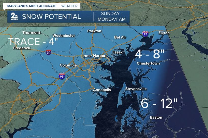
We chose a gradient map for coloring to show the transition of possible totals as you move west. Travel is not recommended from Sunday into late Monday morning.
Relief comes Tuesday, as sunshine returns and temperatures slowly start to warm for the second half of the workweek.

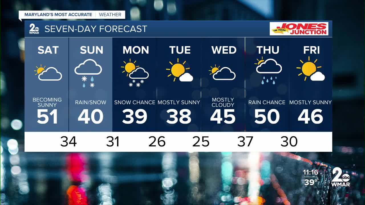
7 Day Forecast:
Saturday Partly sunny, with a high near 51.
Saturday Night A chance of rain mixing with snow. Mostly cloudy, with a low around 34.
Sunday Rain and snow. High near 40.
Sunday Night Rain and snow. Low around 31.
Monday A chance of snow in the morning. Mostly cloudy, with a high near 39.
Monday Night Mostly cloudy, with a low around 26.
Tuesday Mostly sunny, with a high near 38.
Tuesday Night Mostly cloudy, with a low around 25.
Wednesday Mostly cloudy, with a high near 45.+
Wednesday Night A chance of rain. Cloudy, with a low around 37.
Thursday A chance of rain. Mostly cloudy, with a high near 50.
Thursday Night A chance of rain. Mostly cloudy, with a low around 32. Chance of precipitation is 40%.
Friday Mostly sunny, with a high near 46. Chance of precipitation is 30%.
Saturday Mostly sunny, with a high near 48.

