


BALTIMORE — Monday we are expecting severe weather through the afternoon and early evening time frame as a potent cold front moves through the Mid-Atlantic. Ahead of the cold front, increasing moisture will continue to surge into Maryland giving us the fuel needed for these storms. Along with the excess moisture is a push of southerly air that brings in extra warmth so, while it may feel more like summer that just gives us another ingredient to ignite these strong to severe storms.
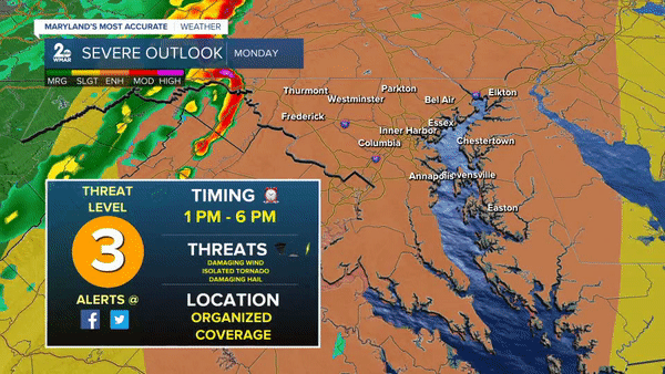
The timing for the storms will be just after lunchtime and continue until about 6-7 PM. The line of thunderstorms will sweep through from western Maryland heading east and finally exiting our area in the later parts of the evening. The drive home is most likely to be impacted as the timing of these storms will line up with the I-95 corridor during rush hour.

The severe threats that we will face are strong damaging winds, large hail, and a tornado could be possible. The biggest concern is the damaging winds which can cause objects to become projectiles and create damage to property. Hail can reach up to an inch or more in size and this could cause some denting to cars. The tornado threat would be brief as this line of storms are more conducive to straight line strong winds. Flooding will be localized as the rain can be heavy at time but the storms will be fast movers.
Overall, Monday will be quite active as the line of thunderstorms move through Maryland in the afternoon and evening time.

