


A Flash Flood Watch continues for Howard, Harford, Anne Arundel, Baltimore, Baltimore City, Carroll, Frederick, Washington, Cecil Queen Anne's, Kent, Talbot, Caroline and Montgomery counties until 6am Tuesday. A Flash Flood Watch means that conditions are favorable for flash flooding to develop while a warning means conditions are imminent.

A powerful cold front continues to blast toward the area tonight with a potent round of showers and thunderstorms. The bulk of the energy is north but storms do look to remain strong based upon lift from the front as well as warm moist air out ahead of the boundary.
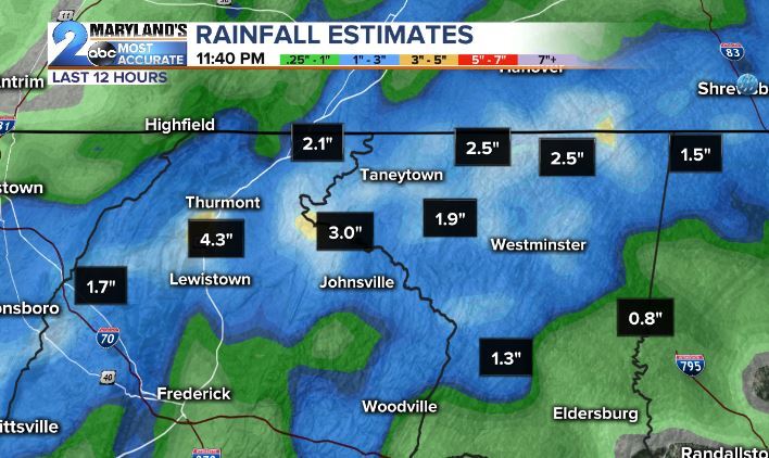

Primary threats of localized flash flooding, vivid lightning, and gusts up to 40 mph continue throughout the area overnight. The front should continue to sag through the area by early Tuesday morning with the heaviest rain before the morning rush. Rain will taper to showers late Tuesday morning into the early afternoon as skies begin the slow clearing process. Humidity will fall shortly after.


Drier conditions expected Wednesday and then again for most of the week/weekend ahead. High temperatures are expected to be at seasonable levels with highs returning to 90 degrees this weekend.

The time is now to remember your weather action plan. Know your safe spot to go and remember when a warning is issued to take immediate action. Make sure you have a way to get weather information, should any alerts be issued. Our WMAR2News app is free for download from the Apple/GooglePlay store. If you can't get alerts by phone be sure to stay with us throughout the day on Facebook and Twitter for the latest updates as storms continue overnight.

