


BALTIMORE — Good Wednesday evening!
The heat and humidity have led to unhealthy air quality in sections of Maryland today. This is due to high concentrations of pollution getting trapped in the lowest levels of the atmosphere. The heat reduces the natural ventilation we see in the atmosphere - trapping unhealthy air near the surface! Those who suffer with respiratory issues should stay inside.
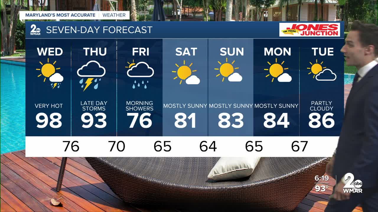
We have one more hot day (Wednesday) before a front slides through Thursday - delivering our next round of heavy rain! The flood threat is moderate Thursday as moisture levels remain high in the upper atmosphere!
Here's the good news - cooler and less humid air arrives Friday! Cloud cover will keep high temps in the 70s! Humidity levels drop drastically, too! To put it in perspective - the dew point today reached the low 70s, but it will fall to the 50s by the weekend! Saturday and Sunday will be an early preview of September, with lower temps and less humidity!

7 Day Forecast:
Wednesday Sunny and hot, with a high near 98. Heat index values as high as 104.
Wednesday Night A slight chance of showers and thunderstorms. Partly cloudy, with a low around 76.
Thursday A chance of showers and possibly a thunderstorm. Mostly cloudy, with a high near 90.
Thursday Night Showers and possibly a thunderstorm. Low around 70.
Friday Showers likely. Mostly cloudy, with a high near 81.
Friday Night Mostly cloudy, with a low around 65.
Saturday Mostly sunny, with a high near 82.
Saturday Night Mostly clear, with a low around 64.
Sunday Sunny, with a high near 83.
Sunday Night Partly cloudy, with a low around 65.
Monday Mostly sunny, with a high near 84.
Monday Night Partly cloudy, with a low around 67.
Tuesday Partly cloudy, with a high near 86.

