


BALTIMORE — Happy Friday!
Hot and humid today with highs in the low-90s. It will feel like the upper-90s with the humidity factored into the equation. Keep an umbrella nearby as there could be a couple of isolated pop-up thunderstorms that quickly develop this afternoon, but the coverage will be minimal. Find ways to beat the heat this weekend as the heat and humidity continue to work their magic. Spotty showers and thunderstorms will be featured both days during the peak heating hours. Storms that form on Sunday could be on the stronger side, so make sure to keep an eye on radar if you have outdoor plans. A cold front brings a renewed chance for widespread rain and storms on Monday. Storm chances diminish into the middle of next week with highs in the low-90s.

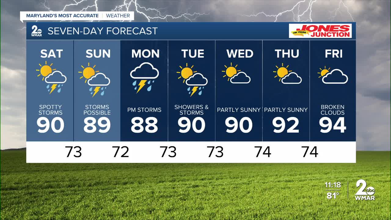
7 Day Forecast:
Today Patchy fog. Otherwise, partly cloudy, with a high near 90. Calm wind becoming east around 5-10 mph.
Tonight Partly cloudy, with a low around 73. Calm wind.
Saturday A slight chance of showers and thunderstorms. Partly cloudy, with a high near 90.
Saturday Night A chance of showers and thunderstorms. Partly cloudy, with a low around 73.
Sunday A chance of showers and thunderstorms. Partly cloudy, with a high near 89.
Sunday Night Showers likely and possibly a thunderstorm. Mostly cloudy, with a low around 72.
Monday A chance of showers and thunderstorms. Mostly cloudy, with a high near 88.
Monday Night Showers likely and possibly a thunderstorm. Mostly cloudy, with a low around 73.
Tuesday A chance of showers and thunderstorms. Partly cloudy, with a high near 90.
Tuesday Night A chance of showers and thunderstorms. Mostly cloudy, with a low around 73.
Wednesday A chance of showers and thunderstorms. Partly cloudy, with a high near 90.
Wednesday Night A chance of showers and thunderstorms. Mostly cloudy, with a low around 74.
Thursday A chance of showers and thunderstorms. Partly cloudy, with a high near 92.
Thursday Night A chance of showers and thunderstorms. Partly cloudy, with a low around 74.
Friday A chance of showers and thunderstorms. Partly sunny, with a high near 94.

