


After 28 days above average including the 8 mild days to kick off 2019, Winter makes a fierce comeback. We are not only talking cold this go around but snow for the weekend ahead. The last time we saw snow in Baltimore was back on November 15th, 2018. During that time we broke a daily record for snowfall of 1.7" beating an old record of 1.2" from 1908. It also marked the earliest snowfall on record since that time frame. From there we went "Snowless" in the month of December which has not happened since 2001.

So you could say we are a bit overdue for some wintry mischief.

We take the polar plunge Thursday and will remain in the Arctic grip through the weekend. The cold of course sets the table for wintry weather as low pressure gathers Gulf of Mexico Moisture in the Deep South. The question remains though to the final track of the storm system as it jogs north and east. Model consensus is starting to come together on a "southern sliding" solution but a range of possibilities remain on amounts and potential timing.

Currently both the European and GFS (American) models have snow coming in Saturday afternoon and lasting through the day Sunday. Each model shows a storm system that jogs through the Mid-south and into the New River Valley of southern Virginia.

This favors a more southerly track as the energy is elongated at the upper levels and displaced from a secondary piece of energy that would meet the storm at the coast. Consensus has shown this over the last 3 runs leaving us to believe that the storm will be on a somewhat drier and quicker track reducing snow totals. Even with that said a wide range of snowfall potential remains based on track uncertainty so check back frequently for the latest snow amounts.


BOTTOM LINE
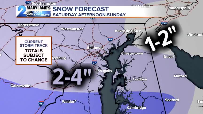
Snow starts up Saturday afternoon and carries us through the day Sunday. Travel disruptions are possible along with scheduling impacts in particularly during the day Sunday as the snow will be at it's heaviest. Amounts look to be around 2-4" across much of Central Maryland with heavier amounts of 4-6"+ over the mountains west of Cumberland and 1-2" down at the Maryland Beaches.
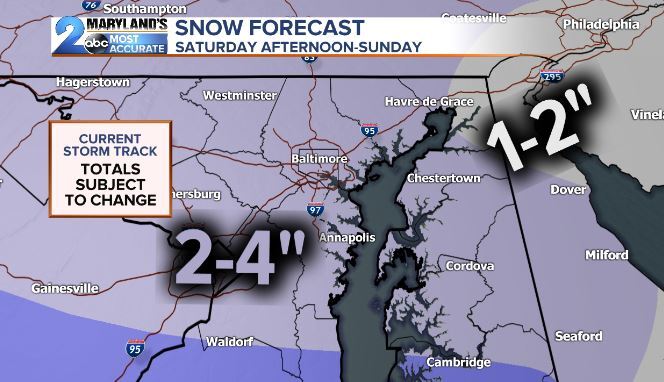
The WORST CASE SCENARIO would be snow amounts of 6" or greater. Confidence though remains low to medium at this time. This is what we would typically see with a slower storm moving up the coast as a Nor'easter arriving from our south.
Our BEST CASE SCENARIO is 1-4" amounts from a quick moving system coming from the west with limited time to catch upper level energy from the Great Lakes to blow the storm up into a big time snow maker. Confidence in this option in medium to high for 1-3" amounts widespread in the Baltimore metro and surrounding counties.

The storm could also MISS US ENTIRELY leading to amounts less than 1" eliminating travel concerns while keeping the heaviest snows west into the mountains and south along I-81. THIS OPTION IS STILL ON THE TABLE WITH THE STORM NOW FORMING IN CALIFORNIA.
Model output through the day Thursday should put the stamp of approval on the final at of the forecast for the weekend ahead. As it stands now accumulating snow is likely but it doesn't look like a big time event. Confidence continues to grow on the "BEST CASE SCENARIO" for at least 2-4" of snow leading to slick travel concerns.


DON'T PANIC
No need to rush for the bread or milk. Just start to think about where you put that shovel or snow brush to clean the car while rearranging your weekend plans for the incoming snow.
Stay weather aware and don't forget to download our free WMAR 2 News mobile app available at the Apple/GooglePlay store. More updates Thursday as conditions unfold.
